 COMMONS AS AN INNER HABIT AND THE IMPACT OF THE OSGEO FOUNDATION
Prof. Dr.-Ing. Franz-Josef Behr
Stuttgart University of Applied Sciences
Prof. Behr is a professor of spatial information processing at the Stuttgart University of Applied Sciences since 2002. He is currently working on topics like Interoperability, open standards, disaster mapping and crowdsourcing.& Free and Open Software/standards/data as applied in teaching and research. He is head of the Laboratory for interoperable, and open-source Geospatial Software, Data and Standards (HFT ICA-OSGeo-Lab). He is co-founder and head of the Applied Geoinformatics for Society and Environment conferences. Besides being a member of the German Organisation for Standardization for Kartographie und Geoinformation., he also serves as co-chair of the ‘Commission on SDIs and Standards’ of the International Cartographic Association (ICA). Since 2016 he is Member of the SDI Advisory Board, State of Baden-Württemberg, Germany. He has published two GIS textbooks, more than 60 scientific papers and gave numerous presentations at international conferences.
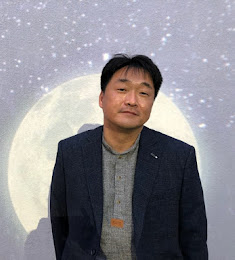
WHERE DO WE COME FROM AND WHERE ARE WE GOING? -15 YEARS PROGRESS OF OSGEO JAPAN CHAPTER
Dr. IWASAKI Nobusuke
Board member of the OSGeo Japan chapter
Dr. Nobusuke Iwasaki has been a board member of the OSGeo Japan chapter since 2007, as Vice Representative since 2014 and Representative since 2018. From 2009 to 2015, He participated in projects of the Japanese Ministry of Education to localize FOSS4G Tools, such as GRASS and QGIS, and to create tutorials. Currently, he is working on the utilization of Web Map tiles for deep learning and the development of map algebra tools using Web GL.
FREE AND OPEN-SOURCE SOFTWARE FOR LAND MANAGEMENT IN NEPAL
Mr. Janak Raj JOSHI
Ministry of Land Management, Cooperatives and Poverty Alleviation
Janak Raj Joshi is a land professional with more than 20 years’ experience. He is currently Joint Secretary at the Ministry of Land Management, Cooperatives and Poverty Alleviation of Government of Nepal. He was involved in different land reform initiatives on policy, legislation and institutional development under the Ministry. He has led the Ministry team to come up with the Land use policy, National Land Policy, legislation reform and Fit for purpose land administration strategy development in Nepal. He holds a M. Sc. Degree in Geoinformation Science and Earth Observation from ITC/ University of Twente, with Distinction. He is actively involved in various research activities and publication on land and tenure governance in Nepal.
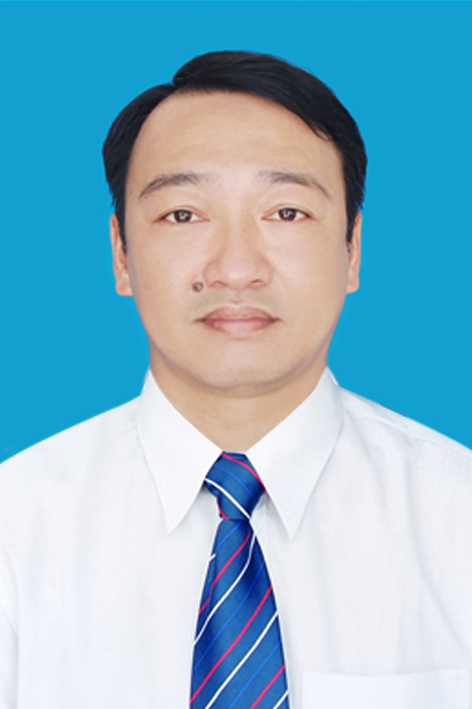
DATA-DRIVEN URBAN PROBLEM SOLVING PLATFORM : COMPAS
Mr. Junho LEE
Ministry of Land Management, Cooperatives and Poverty Alleviation
Junho Lee is a GIS analyst in LH Corp (Korea Land & Housing Corporation), a partner organization of OSGeo in Korea. He has put much of his efforts to disseminate the open source spirits and technologies around my organization. He has organized a local QGIS group in my city and has led the group. Local policemen, students, professors, and other people regularly gathered there together to learn how to use QGIS for their own jobs. He recently wrote and published a book called ‘QGIS Cookbook for Big Data Analysis’ in Korean.
APPLICATION OF OPEN SOURCE SOFTWARE TO BUILD AND DEPLOY SDI SYSTEM FOR THUA THIEN HUE PROVINCE
Dr. Nguyen Quang TUAN
Ministry of Land Management, Cooperatives and Poverty Alleviation
Dr. Nguyen Quang Tuan is currently working as an Associate Professor, Senior lecturer and Vice Dean of GeoSciences Faculty at Hue University of Sciences. He is also the Head of Geodesy and GeoSpatial LAB (GeoLAB), Head of researchers group on Geospatial technologies and Digital transformation, Vice Director of Centre for Coastal Management and Development studies (CMD) and member of the Executive Committee of Vietnam Association of Geodesy, Cartography and Remote Sensing. He has been teaching Soil Sciences, Cartography, GIS and Remote Sensing, Natural Resources Management, Resource and Environment Project management courses to Undergraduate students and Post – graduate students at the Hue University.
4ONSE- LESSONS LEANT FROM FOSS FOR CLIMATE-BASED SERVICES
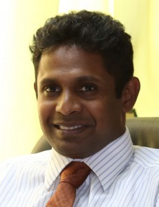
Prof. Rangajeewa RATNAYAKE
University of Moratuwa, Katubedda, Moratuwa, Sri Lanka
Rangajeewa Ratnayake is a Professor in Town and Country Planning, University of Moratuwa and a Chartered Town Planner ( PhD, MSc, BA Hons) with over 19 years of experience lecturing in international and national universities, providing local level land use planning, managerial, operational, and capacity development support for Local Authorities, supervising the preparation of physical plans. His areas of expertise include research in urban planning, Local Authority Level Strategic and Statutory Planning, Local Governance, Social Planning, Participatory Community Planning and Environmental Information Management System (GIS). The central themes of his research agenda involve unravelling the relationship between human behaviour and the built environment. He has researched the complexity of urban settings and the sense of safety concerns. He has recently commenced studying climate sensitive planning and non-conventional systems for sensing environment.
FROM MAPS TO DSS WITH BIG DATA AND MACHINE LEARNING

Dr. Sarawut NINSAWAT
Remote Sensing and Geographic Information Systems FoS, Asian Institute of Technology, Thailand
Dr. Sarawut Ninsawat received the Doctoral degree at Osaka City University (OCU), Japan. He was a Postdoctoral researcher at National Institute of Advanced Industrial Science and Technology (AIST), Tsukuba, Japan. Currently, he is an Assistant Professor and Degree Program Chair Coordinator of Remote Sensing and GIS program, Department of ICT, School of Engineering and technology, Asian Institute of Technology. Currently, he is a Thai OSGeo Chapter Secretary. His research interests are application of Remote Sensing and GIS for natural resource management, developing Web Mapping Application especially focus on the implementation of standard OGC Web services (OWS) framework such as WCS, WFS, WPS and SOS using Open Source Software solutions. Additionally, the various Location-Based Service applications were developed to utilize the location information for agriculture, environment and logistic purpose.
DEVELOPMENT AND CHALLENGES OF OPEN SOURCE GEOSPATIAL TECHNOLOGY IN CHINA
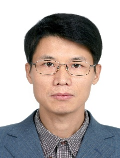
Prof. Xianfeng SONG
College of Resources and Environment, University of Chinese Academy of Sciences
Xianfeng Song works on geo-informatics with a focus on remote sensing hydrology, GIS and environmental modelling, spatiotemporal analysis and modeling particularly on understanding urban human mobility patterns. He heads the GIS Lab in College of Resources and Environment, which aims to promote open-access geographic data based geo-computing and web mapping using the state-of-the-art open source geospatial technologies. His research has been funded by various agencies, including the National Science Foundation of China, National Science and Technology Major Project, and National Key Research and Development Program. He was awarded JSPS Fellowships (2000-2002), Osaka City University Fellowship for Inviting Foreign Researcher (2008), and CSEAS Fellowship for Visiting Research Scholars of Kyoto University (2012). Before joining UCAS, he worked as a postdoctoral fellow (2 years) and assistant Professor (3 years) at the Center for Southeast Asian Studies at Kyoto University from 2000-2005.